Controlled Destruction
At the 2017 Association AGM, Fiona Gale reported on recent finds during
“controlled destruction” (erm, excavations) on and near the Clwydian Range,
including something rather unique at Moel Arthur
Penycloddiau
Penycloddiau is an iron age hillfort top the
Clwydian Range. Excavation of a track through a
rampart revealed a large yet part-collapsed dry
stone wall some 3½ to 4 yards in width that
would have circled the entire site to a length of
some 1½ miles. The wall was constructed as a
box rampart, one cube of stones at a time, and
was therefore made in sections.
Originally believed to be a palisade, the fact that
the wall would have taken such a lengthy period
to build indicates that it was perhaps unlikely to
be for defensive purposes; if protective, those
building it would easily have been over-run well
before it was complete. As such, Fiona
suggested that defence was only believed to be
a tiny function of this massive hillfort.
Indeed, Fiona speculated that the wall was
important in bringing a whole Iron Age
community together and a way of cementing
the group. Given its size, there may have been
up to 80 extended families living there. This was
the total number the area could support,
although they may not have all been there at
the same time. Excavators found mortar atop
the walls. Although the Romans brought in
mortar, that at Penycloddiau was believed to
pre-date this and, as such, is unique other than
at a site in
Gloucestershire.
Moel Arthur
A second
excavation on the
Clwydian Range at
nearby Moel
Arthur revealed a
bronze age clay-
lined trough with stones. It was believed that
those living at Moel Arthur would have heated
these stones by fire and placed then in water in
the trough till the water boiled. This was likely
for cooking (as was the case as late as the 18th
century on the Hebrides) or it may have been
used as a sauna. Carbon dating of the
associated charcoal placed the trough as bronze
age, before the hill fort itself, and Fiona believed
that there may have been activity there as early
as 5,000 BC.
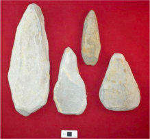
What had taken the imagination of the Welsh
and international media, however, was the
hand-held limestone tools they found. They
were each of a worked triangular shape, the top
part of which appeared to be used to "peck"
other stone.
The National Museum of Wales and other
learned institutions had not seen anything like
this before. As such, the tools are believed to be
unique.
Moel y Gaer
Discovered on this privately-owned hill fort.
near Bodfari, a third excavation site on the
Range, were stone spinning weights. Fiona
suggested that this was evidence that the
inhabitants keep sheep and, as such, here was
both domestic activity and an embryonic rural
economy.
Excavators
discovered a likely
site for a house
and within its
garden a bone
dated to c.350 BC.
There were believed to be three phases of
building at the site, indicated by three banks, in
one of which was the remains of a drystone
wall. Unlike at Penycloddiau, this site and its wall
were much smaller in scale.
Works at Moel y Gaer would, in Fiona’s view,
have made something of an impression. As
such, she again felt that the dwelling would have
housed another community and the structure
would have been more important
psychologically than defensively.
Other Sites
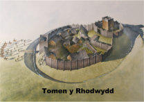
The classic motte and bailey castle called
Tomen y Rhodwydd near Llandegla dates from
c.1167 and therefore was Welsh-built. Till
recently masked by trees and vegetation, the
site was cleared and is now managed. There is
also now permissive access from near the
B5431.
Archæologists have attempted to understand
how the Leete Path at Loggerheads was built.
Its purpose is known: the River Alyn disappears
underground during the summer and the leete
was designed to ensure that early industry in
the area had a continuous supply of water. It
was expected to be a box-section leete but is, in
fact, U-shaped and, as such, carried less of a
volume of water than previously thought.

Town and Around Current Edition
Town and Around Historic Contents
Contact Us
Ruthin Local Historic Society
Copyright © 2018 Ruthin & District Civic Association


